LEO (Low Earth Orbit) and GEO (Geostationary Earth Orbit) satellites differ in several ways when it comes to public safety.
Here are some key differences:
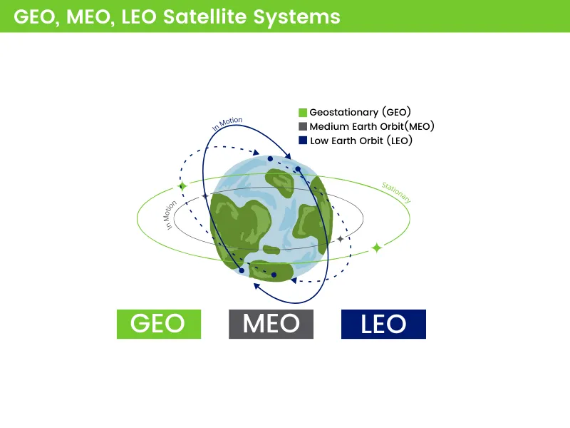
- Orbit Altitude and Speed: LEO satellites orbit much closer to the Earth, typically at altitudes between 99 – 1,200 miles (160 - 2,000 km), while GEO satellites are placed in a fixed orbit at an altitude of approximately 22,300 miles (35,800 km). This difference in altitude results in LEO satellites having much shorter propagation delay providing lower latency communication.
- Footprint Coverage: Due to their lower altitude, LEO satellites provide coverage of smaller areas per satellite, whereas GEO satellites cover larger regions, often an about one-third of Earth’s surface per satellite broken up into separate transponder beams to cover specific geographical locations. LEO satellites make up for this difference by being deployed in large constellations of dozens to thousands of satellites across dynamic orbital positions to achieve global coverage.
- Latency: Latency refers to the time delay between transmitting a signal from Earth to the satellite and receiving a response. LEO satellites have significantly lower latency compared to GEO satellites. GEO satellites have a higher latency, typically ranging from 500-600 milliseconds. Since LEO satellites are closer to the Earth, the signals have a shorter distance to travel, resulting in typical latency ranges from 20-50 milliseconds. This lower latency can be crucial for public safety applications that require real-time communication and response, such as emergency response coordination or remote monitoring of critical infrastructure.
- Constellation and Network: LEO satellites are typically deployed in large constellations consisting of numerous satellites working together. These constellations create a network of satellites that can provide continuous coverage and seamless handoffs as the satellites move across the sky. This networked architecture enables redundancy and improved reliability for public safety applications. On the other hand, GEO satellites operate individually, and their coverage is achieved by positioning multiple satellites at different locations around the Earth.
- Efficiency and Complexity: Although relative costs for individual LEO satellites are relatively lower than GEO, launching and maintaining constellations can be more complex and costly due to the need for a larger number of satellites to achieve desired effective communication. GEO satellites carry a higher per satellite cost for manufacturing and maintaining but operate at a lower cost and complexity. The same is seen in the difference between antennas, with LEO terminals requiring real-time tracking and efficient hand-over systems while GEO terminals are often much simpler and cheaper.
- Agility and Flexibility: LEO satellites are more agile and flexible compared to GEO satellites. Since they are closer to the Earth, LEO satellites can change their orbital position relatively quickly and easily. This adaptability allows LEO satellites to adapt to specific areas of interest or respond to changing public safety needs promptly. GEO satellites, due to their fixed orbit, have limited mobility and cannot be repositioned easily. Any changes in coverage or deployment require launching and placing new satellites in orbit.
- Bandwidth and Capacity: LEO satellites generally offer lower bandwidth per satellite compared to GEO satellites. However, the large number of LEO satellites working together in a constellation can compensate for this limitation by providing higher overall capacity. This increased capacity is beneficial for public safety applications that require large-scale high-speed data transmission, such as high-definition audio and video streaming, remote sensing, or real-time communications for situational awareness.
- Mobility: LEO satellites are in motion relative to Earth’s surface and terminals connect to multiple satellites in a constellation simultaneously. This makes them more suitable for applications that require tracking or communication with moving objects, such as ships, aircraft, and land vehicles. GEO satellites maintain a stationary position relative to Earth’s surface, making them more suitable for fixed communication applications like broadcasting and mid to long-term rural internet access.
Overall, LEO satellites offer significant advantages in terms of lower latency, increased flexibility, and redundant networked constellations, which can be beneficial for certain public safety applications. However, GEO satellites provide broader coverage over larger areas and have higher individual bandwidth capacity, making them suitable for applications that require wide-area coverage and high-bandwidth communication. The choice between LEO and GEO satellites for public safety applications depends on specific requirements, geographical considerations, and the nature of the intended use cases. The introduction of LEO satellite communication is leveling the playing field, ensuring reliable and accessible connectivity regardless of geographic location.
We go into detail about the LEO satellite capabilities for public safety and emergency management, here.
How can I try out these new LEO services?
PEAKE is partnering with multiple providers of LEO satellite service to bring this revolutionary service to our public safety, OEM and DOD customers. SpaceX Starlink and OneWeb are currently the two major LEO satellite market service providers. They are soon to be joined by Amazon LEO, further driving competition to provide more affordable and available service across the globe.
PEAKE offers various solutions that capitalize on the benefits of LEO and GEO satellite communications and bandwidth blending technologies to provide capabilities that meet and exceed operational requirements.
PEAKE is offering virtual demos on these systems as well as our Tactical BLEND Kit solution. Click here to schedule a demo.
Contact us today to learn more about adding LEO Satellite Service to your First Response playbook.